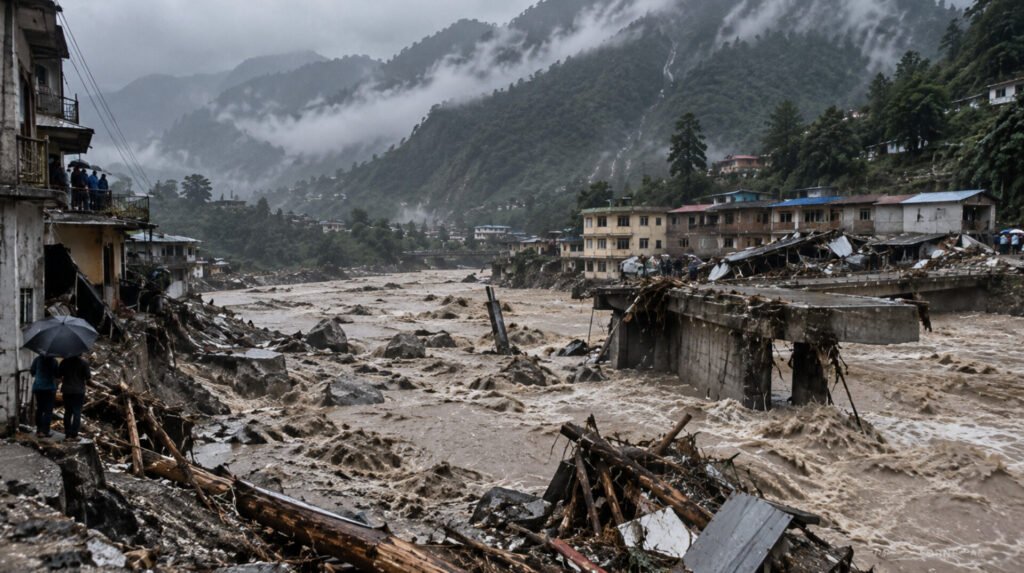
The devastating flood that struck parts of Nepal on August 26, 2026, was not simply a case of monsoon rainfall overwhelming a river.
The disaster appears to have developed through a complex sequence of high-altitude geological and hydrological events. A large-scale collapse involving rock and ice in the Himalayas sent enormous amounts of material into a river system, triggering a destructive downstream flow of water, sediment and debris.
Within a short period, the consequences reached communities, roads, bridges and hydropower infrastructure across the Bhote Koshi and Trishuli corridors.
The disaster has since raised difficult questions about Himalayan climate risks, infrastructure planning and the ability of existing early-warning systems to detect hazards that begin high above the communities ultimately affected.
What Happened on August 26?
The event began in the high Himalayan region near the Nepal-China border.
A major slope failure involving rock and ice occurred at high altitude, generating a powerful movement of material down the mountain. The initial event was significant enough to produce seismic signals that were detected by monitoring systems.
As the collapsed material entered the river system, it became part of a much larger downstream process.
Water mixed with rock, sediment and debris, producing a rapidly moving flow capable of causing far more destruction than a conventional river flood.
The resulting surge travelled through the Lhende Khola and Bhote Koshi river system before affecting communities farther downstream.
This distinction is important.
The August 26 event is commonly described as a flash flood, but the available evidence indicates that it was a multi-hazard event involving a high-altitude slope collapse, debris mobilisation and extreme flooding.
Understanding that chain is essential to understanding the scale of the destruction.
Why the Flood Was So Destructive
Mountain rivers behave very differently from broad lowland waterways.
The Bhote Koshi and Trishuli corridors pass through steep, narrow valleys. Under normal conditions, these geographical characteristics make the rivers powerful but relatively confined.
During an extreme debris-flow event, however, the same terrain can amplify the consequences.
The collapsed material entered the drainage system and was carried downstream at high speed. Along the way, the flow accumulated water and sediment, increasing its destructive capacity.
Instead of water alone moving through the valley, communities were confronted with a mixture of mud, boulders, broken vegetation and other debris.
Bridges became vulnerable to impact and scour.
Roads were undermined.
Buildings close to the river were exposed to rapidly moving water and sediment.
Hydropower facilities located along the river system were also placed directly in the path of the disaster.
The Rapid Rise of the Trishuli River
The speed of the downstream response was one of the most concerning aspects of the disaster.
At some locations, river levels rose dramatically within a matter of minutes.
Reports from monitoring stations indicated a rise of approximately nine metres at Galchhi within around half an hour, while similarly rapid changes were observed elsewhere along the river.
For communities living downstream, such a rapid increase presents a serious warning challenge.
Traditional flood forecasting often relies heavily on rainfall measurements and river-level monitoring. Those systems can be highly effective for many types of floods.
But when the initiating event is a sudden mountain collapse, the available warning time can be considerably shorter.
By the time a river gauge records an extreme change, the destructive flow may already be moving rapidly toward downstream settlements.
Rasuwa and the Border Corridor
The disaster caused severe damage in Rasuwa District, including areas around the northern border and the Rasuwagadhi corridor.
The region is strategically important because it connects Nepal with China through one of the country’s major Himalayan trade routes.
Road infrastructure in the area was heavily affected, disrupting transportation and access to communities.
The destruction also complicated the movement of emergency responders and relief supplies.
For isolated mountain communities, the loss of a bridge or road is not merely an infrastructure problem.
It can determine whether food, medicine, rescue personnel and communications can reach them.
The Impact on Hydropower
Nepal’s hydropower sector was among the most severely affected parts of the economy.
The Bhote Koshi and Trishuli river systems have significant hydropower potential, and several projects operate along their valleys.
The August disaster damaged numerous hydropower facilities and associated infrastructure.
The consequences extended beyond physical damage to power stations.
Access roads were destroyed or blocked, transmission infrastructure was affected, and workers at some facilities were placed in extremely dangerous situations.
Reports of workers trapped inside hydropower tunnels added another dimension to the rescue operation.
In some cases, rescuers had to work through flooded or debris-filled infrastructure while simultaneously dealing with unstable terrain and damaged transportation networks.
The incidents demonstrated how closely Nepal’s energy infrastructure is tied to the country’s mountainous geography—and how vulnerable that infrastructure can become when multiple hazards occur simultaneously.
The Human Cost
Behind the infrastructure damage is a much more serious human tragedy.
Communities along the affected river corridors lost homes, businesses and sources of income. Families were separated, while search-and-rescue teams continued looking for people reported missing.
By early September, the number of deaths reported across the affected areas had risen into the thousands, with many people still unaccounted for.
The final human cost may take considerable time to establish.
Mountain disasters create particular difficulties for identification and recovery because roads can disappear, communication networks can fail and large quantities of sediment can bury affected areas.
For families waiting for information, the uncertainty can be as devastating as the physical destruction.
Was Climate Change Responsible?
Climate change is inevitably part of the discussion surrounding a high-altitude Himalayan disaster.
The region is experiencing significant changes in temperature, glacier mass and the stability of frozen mountain environments.
However, it would be scientifically premature to claim that climate change directly caused the specific slope failure on August 26.
The relationship between climate change and individual mountain disasters is complicated.
Warming can alter glaciers, permafrost and the structural stability of high-altitude terrain. It can also change the timing and intensity of snow and ice melt.
But determining whether a particular collapse was directly triggered by climate change requires detailed geological, meteorological and glaciological analysis.
The more immediate concern is the broader trend.
As the Himalayan environment changes, Nepal may increasingly have to prepare for hazards whose behaviour does not fit traditional categories.
A New Challenge for Early-Warning Systems
The August 26 disaster exposes an important limitation in conventional disaster preparedness.
Flood-warning systems primarily monitor what happens to water.
But in the Himalayas, the source of the threat can be much higher.
A slope can fail before a river begins to rise.
A landslide can block a river and subsequently release a sudden surge.
A glacier or ice-rock collapse can generate a debris flow that reaches downstream communities before conventional warning systems have enough time to respond.
This suggests that Nepal’s future disaster-management strategy will need to integrate multiple forms of monitoring.
Satellite imagery, seismic observations, glacier monitoring, slope-stability assessments, river gauges and community-level warning systems will all have an increasingly important role.
The goal should not simply be to detect floods.
It should be to detect the events capable of creating floods.
Development and Risk in the Himalayas
The disaster also raises questions about how infrastructure is planned in mountain environments.
Nepal needs roads, hydropower, bridges, tourism facilities and economic connections.
At the same time, many of these developments necessarily occupy narrow valleys where exposure to natural hazards is high.
Historical flood records can help engineers understand normal risks, but they may not adequately represent extremely rare events involving massive debris flows or high-altitude collapses.
The August 26 disaster therefore provides an opportunity to reassess infrastructure standards.
Future projects may need to consider not only expected river discharge, but also the possibility of sudden sediment pulses, large boulders, landslide-generated waves and cascading hazards.
The Disaster Crossed Borders
The consequences of the August 26 event were not confined to Nepal.
The affected river system connects with larger waterways that continue south toward India.
This demonstrates the inherently transboundary nature of Himalayan disasters.
A geological event in a remote mountain region can affect communities across international borders within hours.
That makes regional cooperation increasingly important.
Nepal, China and India share interconnected mountain and river systems, and information about major upstream hazards can have direct implications for populations downstream.
Improved cross-border communication could become an important component of future disaster preparedness.
What Nepal Can Learn From August 26
The immediate priority after the disaster is recovery.
But the longer-term challenge is prevention.
Several lessons stand out.
First, Himalayan disaster monitoring needs to look beyond rainfall.
Second, critical infrastructure in high-risk valleys requires stronger consideration of cascading hazards.
Third, communities need warning systems that can deliver information rapidly at the local level.
And finally, scientific monitoring needs to be connected more effectively with emergency response.
A warning is useful only if it reaches people in time and provides clear instructions about what they should do.
Beyond a Single Flood
The August 26 disaster should not be viewed solely as another extreme monsoon event.
It demonstrated how a hazard beginning in an apparently remote mountain environment can rapidly evolve into a national emergency.
A slope failure can become a debris flow.
A debris flow can become a flood.
A flood can destroy roads and bridges.
The loss of infrastructure can then slow rescue and relief operations, increasing the consequences of the original event.
This is the nature of cascading disasters.
And it may be one of the most important concepts for Nepal to consider as it plans for the future.
A Warning From the Himalayas
The August 26 flood left a trail of destruction through some of Nepal’s most challenging terrain.
But its significance extends beyond the immediate damage.
The event has demonstrated the growing complexity of hazards in the Himalayan region and the difficulty of predicting disasters that involve several natural processes at once.
For Nepal, the challenge now is not simply rebuilding what was destroyed.
It is determining how to rebuild more safely.
That means better monitoring, stronger infrastructure standards, improved evacuation planning and closer cooperation between scientists, government agencies and local communities.
The Himalayas will continue to change.
Rivers will continue to flow through steep valleys.
Mountains will continue to experience landslides, avalanches and slope failures.
The question is whether Nepal can ensure that the next mountain hazard does not become another catastrophe on the same scale.
August 26 was not simply a flood. It was a demonstration of how quickly a high-altitude mountain event can become a human disaster far downstream.